top of page


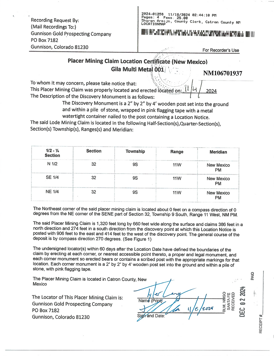
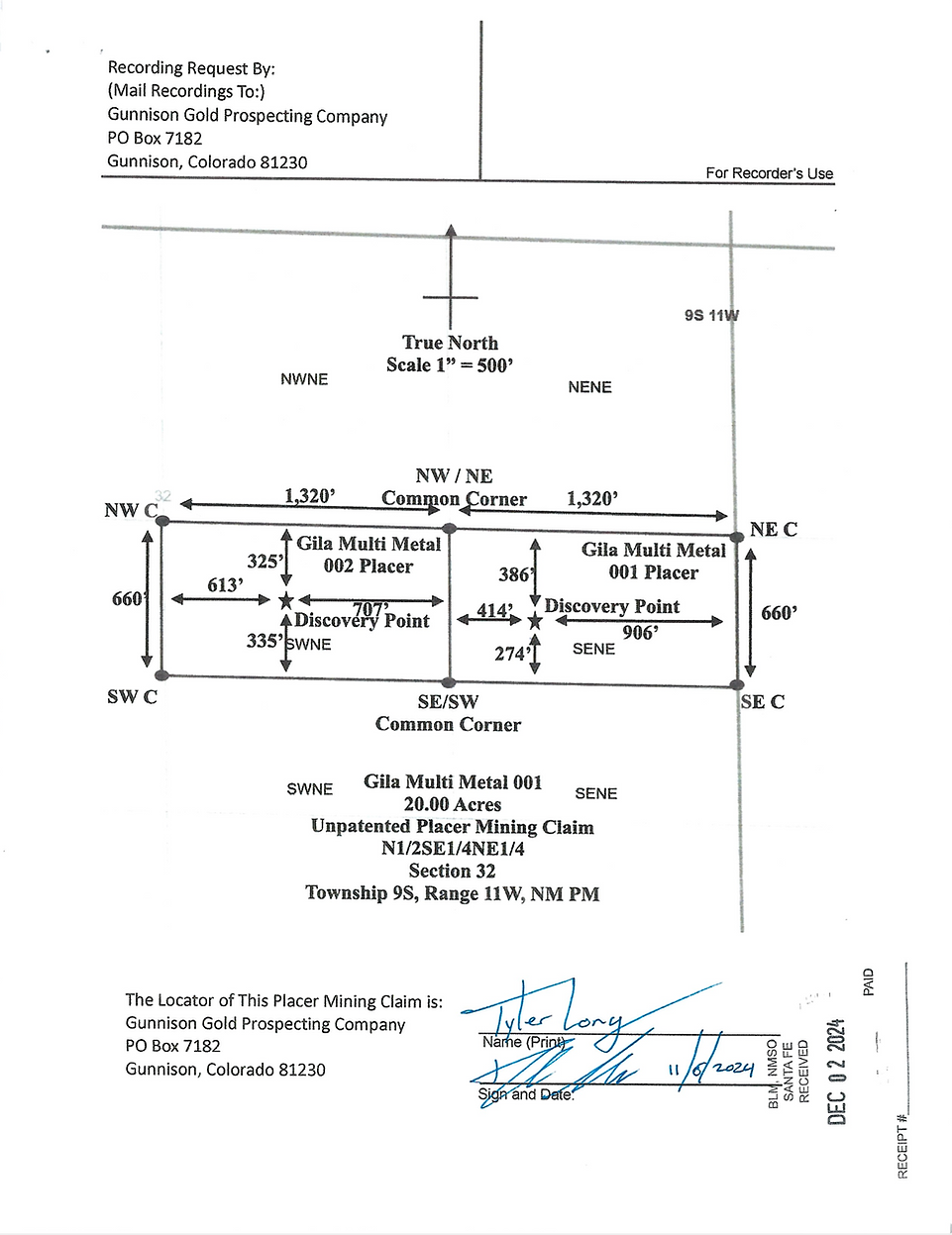
Gila Multi Metal 001
20.00 Acres
Unpatented Placer Claim
NM # 106701937
Catron County, New Mexico
Price: 2,750 USD
Primary Metal
Gold, Fluorine - Fluorite, Tellurium, & Tin
Size
Flake & Fines
Financing
Buy the Gila Multi Metal 001 Unpatented Placer Claim for 2,750 USD outright.
Or
Finance the claim with 750 USD down and a monthly payment of 500 USD for 4 months.
Claim Features
Multiple Minerals Present
Claim Status
Active
Overview
Located on the geologically diverse Gila National Forest the Gila Multi Metal 001 placer claim is a remotely tucked away claim that has road access.
Noted by the USGS (US Geologic Survey) to contain a mix of minerals and metals; gold, tellurium, tin, and fluorine -fluorite can be found on this claim.
The benefit to mining is New Mexico is of course the year round weather. Add in the monsoon season which usually deposits fresh gold into the washes and alters the stream course you have a new challenge and opportunity every year on this claim.
Geology
Commodity
Fluorite
Importance
Tertiary
Commodity
Gold
Importance
Tertiary
Commodity
Tellurium
Importance
Tertiary
Commodity
Tin
Importance
Primary
Ore Body
Gila Group
Numerous hard rock mines have operated in close proximity to this placer claim including the Silver Monument, Blackwater Gulch, Stiletto Mine, and many other unlisted mine shafts and adits.
Water is scarce on this claim. So be prepared to work the claim without water during the dry months. This could be accomplished by rock hounding for non metallic rocks & metal detecting for gold. Tin is also found on this claim and is the primary mineral on this claim.
Camping
Dispersed Camping not allowed on this claim. There are numerous alternative dispersed camping areas within the Forest close to the claim.
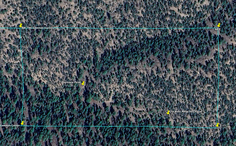
Claim Map
Satellite Claim Boundary Overlay
Access
This claim is located approximately 5 miles from highway 59; from the highway you can access the claims via dirt Forest Service Roads. A 4WD pickup truck or ATV/UTV is recommended.
Recommended Gold Recovery Methods
Dry Washing, Metal Detecting, Crevicing, Rock Hounding
Land Ownership Status
Forest Service
Gila National Forest General Area Info
The Gila National Forest is one of the largest National Forests in the lower 48 states. Covering over 3 million acres the forest boasts relatively warm winter, cool summer temperatures and is host to many large and small mining operations in the present and past.
Quality dispersed camping sites are found within the National Forest boundaries.
Prospecting, hunting, and ATV/UTV riding is very popular in the Forest. Recently overloading camping adventures have found amazing multi day routes thru the forest covering magnificent view from barren desert to highly timbered areas.
What Is Included In The Purchase
-
Quit Claim Deed
-
Google Earth Map
-
Waterproof 24X36 hardcopy 1:24,000 Map
-
Corner & Discovery Point GPS Coordinates
-
2 Hours of Free Complimentary Consulting
-
Certificate of Location Copy
Prospecting Disclaimer
The Gila Multi Metal 001 Unpatented Placer Claim NM# 106701937 is an Unpatented Federal Mining Claim. Any form of mining or prospecting is barred without prior approval from Gunnison Gold Prospecting Company. This website listing does not constitute or convey approval from Gunnison Gold Prospecting Company to mine or prospect the claim in any capacity. Mineral theft is a Federal offense and is prosecuted to the fullest extent of the law as listed in the 1872 Federal Mining Laws.
Next Steps
-
Contact Me
-
Setup A Prospecting Day if you would like to test the claim before purchase (Optional)
-
Buy Outright or Finance In House
Contact Information
Tyler Long
Lead Prospector
Gunnison Gold Prospecting Company
Direct Line: 970-901-9043
tyler@gunnisongoldprospecting.com


bottom of page