top of page


Cross Creek 002
20.00 Acres
Unpatented Placer Claim
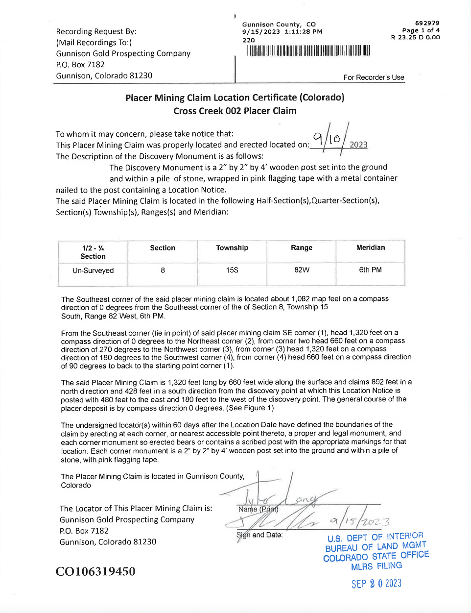
CO # 106319450
Cross Mountain Mining District
Gunnison County, Colorado
Price: 8,500 USD
Primary Metals
Gold, Copper, Manganese
Size
Flakes & Fines
Claim Status
Active
Claim Features
4WD Access
Consistent Water Flow
Surface Workings
Payment Plan
Option (1)
Down Payment 4,250 USD monthly payment 708.33 USD for 6 months. No Interest.
Option (2)
Down Payment 3,400 USD monthly payment 425 USD for 12 months. No Interest.
Overview
Featuring 1,100 linear feet of Cross Creek flowing thru the claim. This claim is located downstream of several gold bearing lode sources such as the Wahl lode system.
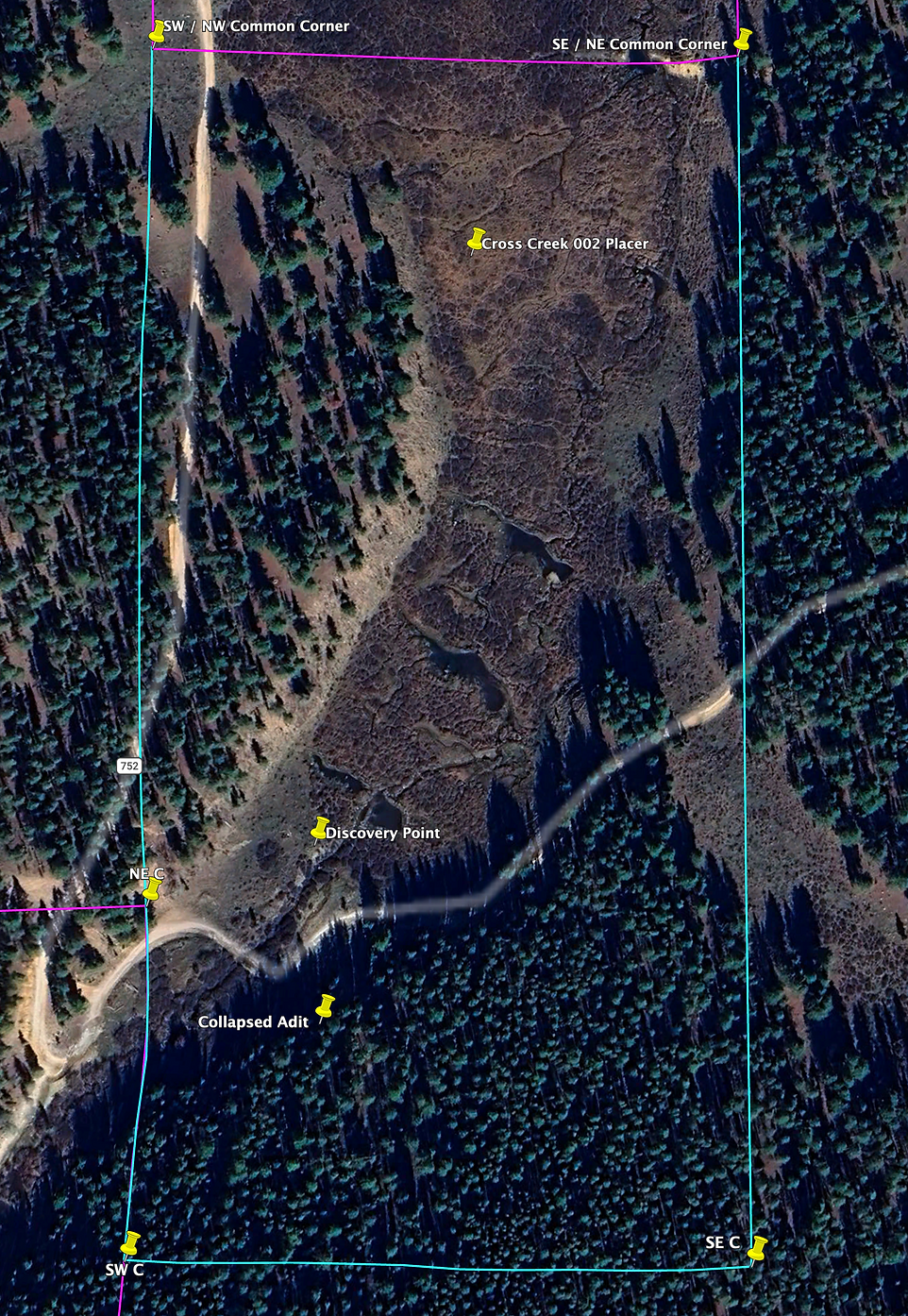
The road system does go thru the claim making for easy access to the stream and the surrounding benches. This claim was worked small scale by previous miners with rudimentary methods dating back to the late 1800's as were most placer creeks in the district. There is remnants of their work in the form of old cobble hand stacks, dilapidated miners cabins, and one small collapsed adit to an underground prospect on the claim.
Most of the gold is going to be in the fine to flake gold form and generally quite pure at 91 fine. Gold found in this creek is either found within the creek bed or high up on dry benches that now sit above the current high water mark.
As with many other creeks in the district this claim as a blue / reddish hued clay layer that acts as a false bedrock. Most recreational miners hit this false bedrock and stay on top of this layer. To get beneath this false bedrock layer a mechanized style of mining would be needed with supporting mining permit.
The top 12" to 18" from surface is covered in organic vegetation / topsoil layer. There is no gold in this layer. Beneath the topsoil there is a layer of unconsolidated alluvial material. Some fine gold can be found in this layer, but I would not classify this layer as a true paystreak due to the large volume of loose cobble and the inability to retain fine materials such as black sand and gold. Most of the mineralization has simply settled below the unconsolidated layer barring any anomalies such as past exposed areas that were missed by the old timers, large boulders, bench deposits, etc. In short, novice prospectors will struggle with this claim if there not a significant degree of prospecting experience.
History
The Union Park area was located by a group championed by Fred Lottes in approximately 1861. Once discovered the Union Park area was worked by rudimentary small scale means into the early 1900's. After WW2 the area has sat predominately idle outside of small independent mining interests such as the dredge on West Willow Creek several miles to the East of Union Park.
The source of much of the mineralization found on Cross Creek 002 has been weathered and eroded from the Wahl mine, which was a gold, copper, and manganese deposit located upstream from the claim. The gold was found in free milling in quartz and associated with limonite and malachite. The source vein is a replacement ore body associated with the Ordovician Fremont limestone what is located below the Devonian Parting Formation, also commonly referred to in the district as Fairview Shale.
Small flat lenses of copper-iron sulfides in quartz and calcite gangue host much of the lode source mineralization. Ore zones were 10 to 15 feet long and 3 to 6 feet wide. A known indicator of ore emplacement is a 10 foot thick sill of hornblende monzonite porphyry which occurs in Devonian rocks just above the ore zone.
Claim Topo Map
Access
4WD vehicle or UTV / ATV access is recommended. The final 1.5 mile approach to the claim is the roughest section with a width restriction in place that will not allow and dually configured vehicles or large trailer to pass. Additionally, the final approach road has extremely rough / angular rock.
The road system from Taylor Reservoir to the beginning of the final approach is approximately 6 miles in length and is Forest Service dirt road, passable by any standard pickup truck / suv.
Camping
Camping is allowed for up to 14 continuous days. If you camp in a towable camper it is recommend to camp between Taylor Reservoir and the beginning of final approach road which has ample dispersed camping spots on the Northern side of Union Park.
These Northern side dispersed camping spots can accommodate large fifth wheel style campers without issue, to then commute several miles to the claim each day with more ideal vehicles.
Mining Permits
Any surface disturbance greater than casual / recreational usage will likely require a mining permit & plan in place before beginning operations. Contact us for mining permit consultant recommendations should you desire to go beyond metal detecting, gravity river sluicing, gold panning, etc.
High Banking, Dredging, or any other similar activity will absolutely require a permit before operations can begin.
Seasonality
Due to the high elevation nature of this mining district (9,900') the general season dates are May 15th thru October 15th of each year. Occasionally, claim owners can work into the end of October to the beginning of November if the cold can be tolerated. Outside of the above listed mining season the claim is inaccessible due to the sheer amount of snow volume this area receives over the winter months.
Satellite Claim Map
Metal Detecting
The greater Union Park area has produced up 1/4 ounce nuggets located mainly on pediments well outside of the flowing stream course on areas the glacial activity did not reach. To metal detect effective in this district a basic gold monster 1000 or similar VLF detector will not suffice. The depth of organics in the topsoil render these detectors 100% ineffective of punching thru this layer to detectable gravels.
Should you decide to metal detect effectively a pulse induction machine with a DD or a large 32" concentric coil is absolutely mandatory. Mono coils do not work well in the Union Park area. My personal preference for a DD coil is a 15" Detech coil powered by a minelab GPX 5000 pulse induction machine.
Owner Thoughts
Having owned this claim since September of 2023 the Cross Creek area has been a significant training ground for myself; namely to parse out the relationship between glacial activity and strong upstream gold bearing lode sources with specific interest on the "contact point" between glacial interference, traditional alluvial gold weathering / erosion, and past 1800's era miner workings.
As I continued to explore the district and expand upon numerous limited reports from the late 1800's to the 1960's it's become apparent that for the conventional recreational miner working in and around the creek system; that the old timers in the 1800's mined the creek in a very sporadic nature the further up Cross Creek towards the source.
These undisturbed pockets still have quality mineralization left within them. Additionally, the areas previously mined still contained fine gold, likely due to the inefficiencies of the sluice boxes at the time. What really caught my attention and completely changed my outlook for the district were the benches / pediments, located high outside the flowing stream course and often associated with timbered areas. The pediments that were immune from glacial interaction proved fruitful with a professional metal detector and was the focus of the majority of my work the past two prospecting seasons.
In summary, most of the high benches on this claim were swept with a metal detector. I'm certain some benches were not hit, and some targets still may exist in the area's that were swept with a detector. Metal detecting even with a pro model is still a somewhat unpredictable way to locate gold given the challenging ground conditions. The area in and around the creek certainly would make a traditional recreational placer prospector content.
The weather at high elevation is quit intense early and late season with morning temps in the neighborhood of 15 degrees, during the summer afternoon thunderstorms are almost a guaranteed.
The Forest Service road that runs thru the claim is not immune from moderately heavy UTV traffic during the peak summer months with large 6 + groups of riders coming thru often. Consequently, every year the final 1.5 mile approach on the Forest Service road has gotten continually worse with topsoil being eroded leaving very sharp rocks almost continually lining the road bed. I anticipate this will continue to get worse every season.
The theft of claim stakes for the claim corners and discovery point on Cross Creek is one of the worst areas in Gunnison County. It's commonplace to replace most stakes in the spring and fall due to theft. I have no solid reason as to why this area is worse for theft than other creeks.
The yearly maintenance fee is paid up till 09/01/2027.
Recommended Gold Recovery Methods
Gravity River Sluicing, Gold Panning, Metal Detecting
Land Ownership Status
Forest Service
What Is Included In The Purchase
-
Quit Claim Deed
-
Google Earth Map
-
Waterproof 24X36 hardcopy 1:24,000 Map
-
Corner & Discovery Point GPS Coordinates
-
2 Hours of Free Complimentary Consulting
-
Certificate of Location Copy
Prospecting Disclaimer
The Cross Creek 002 Unpatented Placer Claim CO# 106319450 is an Unpatented Federal Mining Claim. Any form of mining or prospecting is barred without prior approval from Gunnison Gold Prospecting Company prior to purchase without express written permission. This website listing does not constitute or convey approval from Gunnison Gold Prospecting Company to mine or prospect the claim in any capacity. Mineral theft is a Federal offense and is prosecuted to the fullest extent of the law as listed in the 1872 Federal Mining Laws.
Next Steps
-
Contact Me
-
Setup A Prospecting Day if you would like to test the claim before purchase (Optional)
-
Buy Outright or Finance In House
Contact Information
Tyler Long
Lead Prospector
Gunnison Gold Prospecting Company
Direct Line: 970-901-9043
tyler@gunnisongoldprospecting.com
Copies Of Original Placer Claim Location Certificate


bottom of page